Stanislaus River System — Sediment Sequence DPS-017 to DPS-020
- Jan 1
- 4 min read


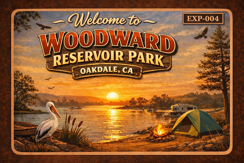
Stanislaus River System
Location: Knights Ferry → Woodward Reservoir, California
System: Stanislaus River / Sierra Nevada
Sample Set: DPS-017 to DPS-020
Sites: 2 (Knights Ferry · Woodward Reservoir)
Samples: 4
Focus: Sediment transport sequence
System States: Transport · Storage · Deposition · Lithification
Material: Quartz-dominant fluvial sediment with mafic fragments
Field Method: Direct collection · visual inspection · comparative analysis
Linked System: Deep Time — Stanislaus River System
Status: Field-collected and interpreted within system context
____________________
Collection Overview — Stanislaus River System
Sediment eroded from the Sierra Nevada moves through a sequence of transport, storage, redistribution, and deposition. These samples capture that progression across a single system—from active river channel to early-stage rock formation within the reservoir.

___________________
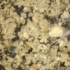
DPS-017 Knights Ferry (Wet Channel) — Foothill Transition Zone
System State: Active Transport
Material Description:
Loose, uncemented sediment
Poor to moderate sorting (mixed grain sizes)
Sub-angular grains with limited rounding
Quartz-dominant with dark mafic fragments and minor iron staining
Process Interpretation:This material is actively transported by the Stanislaus River under relatively high-energy conditions. Grain angularity and mixed sizes indicate ongoing movement with limited reworking or long-distance transport.
System Role: Sediment in motion

_______________________
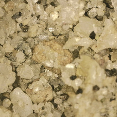
DPS-018 Knights Ferry (Bank) — Temporary Storage Zone
System State: Short-Term Storage
Material Description:
Loose sand with slight compaction
Moderately mixed grain sizes
Sub-angular to sub-rounded grains
Similar quartz-rich composition with minor oxidation
Process Interpretation:Deposited during higher flow conditions and left behind as water levels recede. Exposure leads to drying, minor sorting, and early surface weathering, but the material remains easily reactivated by future flow.
System Role: Sediment paused, not settled

___________________
DPS-019 Woodward Reservoir
alluvial plain / race course terrain
Woodward Reservoir (Course Surface) — Transitional Margin
System State: Deposition + Reworking
Material Description:
Loose to lightly compacted sediment
Mixed grain sizes with fine material filling gaps
Quartz grains with dark mineral fragments and organic inclusions
No true cementation
Process Interpretation:Sediment deposited during high water stages is later exposed during reservoir drawdown. Fluctuating conditions introduce drying, minor redistribution, and surface disturbance, creating a mixed and unstable deposit.
System Role: Sediment in transitionn

____________________
DPS-020 Woodward Reservoir (Shoreline Rock) — Low-Energy Depositional Zone
System State: Early Lithification
Material Description:
Quartz-rich with iron-stained matrix
Patchy cementation
Smooth, water-polished surface
Process Interpretation:Reduced water energy allows suspended sediment to settle and remain in place. Over time, chemical binding and compaction begin to stabilize the material, while shoreline processes smooth and modify the surface.
System Role: Sediment becoming rock

____________________
System Sequence
This collection captures a complete sedimentary progression:
Location | System State | Process |
Knights Ferry (Wet) | Active | Transport |
Knights Ferry (Bank) | Intermediate | Temporary Storage |
Woodward Course | Transitional | Deposition + Reworking |
Woodward Shoreline | Settled | Early Lithification |
Core Interpretation
Sediment eroded from the Sierra Nevada is transported through the Stanislaus River, temporarily stored along riverbanks, redistributed across reservoir margins during fluctuating water levels, and ultimately deposited and bound into early-stage rock within the low-energy environment of Woodward Reservoir.


This is not just a set of samples—it is a continuous system captured in stages
Movement>Pause>Redistribution>Settlement
Summary
This collection captures the Stanislaus River system in sequence—from high-energy transport at Knights Ferry, to temporary storage along the banks, to redistribution across the Woodward Reservoir margins, and finally to early-stage lithification along the shoreline. Each sample marks a point in that progression, showing how material from the Sierra Nevada moves, settles, and begins to become rock.
______________________
Deep Time | Race Review | Night Sky Archive
_____________________
References
Blair, T. C., & McPherson, J. G. (1994). Alluvial fans and their natural distinction from rivers based on morphology, hydraulic processes, sedimentary processes, and facies assemblages. Journal of Sedimentary Research, 64(3a), 450–489. https://doi.org/10.1306/D4267DDE-2B26-11D7-8648000102C1865D
Knighton, D. (1998). Fluvial forms and processes: A new perspective. Arnold.
Mack, S., & Saucedo, G. J. (1988). Geologic map of the Oakdale quadrangle (Regional Geologic Map Series, Map No. 4A, scale 1:250,000). California Division of Mines and Geology.
Ransome, F. L. (1898). Some lava flows of the western slope of the Sierra Nevada, California. U.S. Geological Survey Annual Report, 18(Part 2), 471–492. https://doi.org/10.3133/ar18_2
Wakabayashi, J., & Sawyer, T. L. (2001). Stream incision, tectonics, uplift, and evolution of topography of the Sierra Nevada, California. Journal of Geology, 109(5), 539–562. https://doi.org/10.1086/321962
Reference Notes
Notes drawn from a linked working system spanning field observation, sample collection, and geological interpretation.
Hand Sample Clock: Which Lab Methods Answer Which Time Questions
Sampling a Stratigraphic Section — What to Collect to Resolve Time and Process
Bounding ranges as active ingredients — Sierra and Coast Range uplift/tilt set gradients, drainage, and sediment routing into the Valley (Howard, 1979)
Faulting as a hydro-geomorphic control — tectonic structures steer rivers, influence incision, and localize floodplain behavior (Harwood & Helley, 1987)
Foothills roadside signature — bedrock control appears where rivers leave the Sierra and cut resistant arc rocks (Alt & Hyndman, 2000)
Sacramento Valley terraces — stepped surfaces as time-slices of river incision and fan building (Alt & Hyndman, 2000)
Terraces and fans as time slices — Quaternary surfaces organize relative age and river history in the Oakdale region (Marchand & Allwardt, 1981)