The River’s Long Argument With Gravity — Stanislaus River Deep Time
- Jan 1
- 5 min read


EXP-004|DT-004
Location: Knights Ferry → Woodward Reservoir, California
System: Stanislaus River / Sierra Nevada
Focus: Sediment transport and landscape evolution
Time Scale: ~250 million years to present
Key Processes: Tectonic uplift · magmatism · erosion · deposition · volcanic rerouting
Terrain Type: Metamorphic foothills → granitic source → alluvial basin
Field Method: Visual observation · terrain interaction · sample collection (Dirt Project cross-reference)
Linked Systems: Dirt Project · Deep Time · Race Terrain Analysis
Field Images
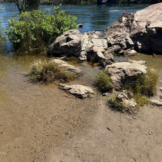
Knights Ferry — Bedrock exposure · erosion zone
Knights Ferry — Active channel · confined flow
Woodward Reservoir — Alluvial surface · depositional terrain
Woodward Reservoir — Soil profile · layered sediment
This Deep Time entry examines the geological evolution of the Stanislaus River system between Knights Ferry and Woodward Reservoir in California. It traces how tectonic uplift, volcanic events, and long-term sediment transport from the Sierra Nevada created the alluvial landscape that defines the Central Valley today.
_______________________
The Landscape: Knights Ferry to Woodward Reservoir


Te Landscape Between Knights Ferry and Woodward Reservoir
The stretch between Knights Ferry and Woodward Reservoir looks simple at first—foothills giving way to flat valley land. But this short corridor holds something more: an entire geological story, readable in the terrain if you know what to look for. This page traces how the Stanislaus River moves material out of the Sierra Nevada and builds the alluvial landscape of California’s Central Valley over millions of years.
I didn’t know any of this when I first raced here. I noticed the ground first—the shift in footing near Oakdale, the texture of the banks at Knights Ferry, the way the soil moved underfoot at Woodward. That was enough to start pulling on threads. This is what they led to.

What Came Before the River
The foothills east of Knights Ferry aren't just hills. They're a compressed record of ancient tectonic collision — oceanic crust scraped onto the edge of North America during the Triassic and Jurassic periods, roughly 250 to 150 million years ago. That collision built the raw material of the Sierra Nevada (Bateman, 1992).
During the Cretaceous — 120 to 80 million years ago — massive bodies of magma pushed upward through the crust but never broke the surface. They cooled slowly underground into granite. That granite is the Sierra Nevada's core, and it is the source material the Stanislaus River has spent millions of years dismantling and carrying west (Wakabayashi & Sawyer, 2001).
By the Oligocene, around 30 million years ago, the range was rising, rivers were steepening, and erosion was accelerating. The valley floor you race on started accumulating then — grain by grain, flood by flood (Huber, 1981).

Where the River Changes
At Knights Ferry, the river exits a canyon of hard rock. That's the last of the old geology holding it in. West of that point, gradient drops, velocity drops, and instead of cutting through material the river starts depositing it.
Everything from Oakdale to Woodward Reservoir is built from transported Sierra Nevada — granite and volcanic rock broken down and moved grain by grain over millions of years (Mack & Saucedo, 1988).
Knights Ferry is where the system changes hands. Everything west of it is the river's long argument with gravity, written in sediment.
When the Volcano Rerouted Everything
About 10 million years ago, during the Miocene, lava flows filled the original Stanislaus River channel. Over time, the softer surrounding rock eroded away — but the hardened lava didn't. The old riverbed became elevated. What was once a low canyon is now Table Mountain, rising above the valley (Ransome, 1898; Piper et al., 1939).
The sequence is worth sitting with:
The river runs through a low channel. Lava fills and hardens it. Surrounding rock erodes faster than the lava. The former riverbed becomes a ridge. The river is forced into a new path and carves a new canyon.
The canyon at Knights Ferry — the one you cross the covered bridge over — is that new path. It didn't exist before the volcano. Table Mountain is the proof of what used to be there.

Woodward Reservoir Is the End of the Story
By the time the river reaches Woodward it has almost no energy left. Sediment is fine, slopes are flat, water spreads and slows. The reservoir sits on deep layers of alluvial material — the accumulated output of millions of years of erosion upstream. The race course terrain is that material: poorly consolidated, variable underfoot, draining fast after rain and shifting under load. It moves the way it does because it isn't really ground. It's a deposit. It's still settling (Bull, 1977).


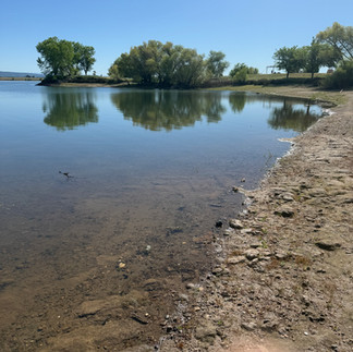

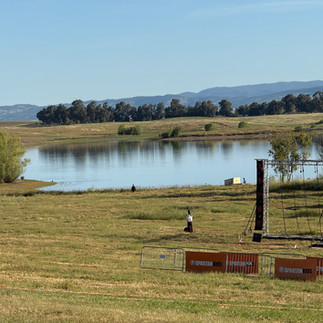
Woodward is where the process comes to rest. Every step you take on that course is a step across the end product of 250 million years of mountain building, river cutting, volcanic interruption, and sediment transport. The ground squirrels are just the most recent thing to move it around.
_____________________
References
Bateman, P. C. (1992). Plutonism in the central part of the Sierra Nevada batholith, California (U.S. Geological Survey Professional Paper 1483). U.S. Government Printing Office. https://doi.org/10.3133/pp1483
Bull, W. B. (1977). The alluvial-fan environment. Progress in Physical Geography, 1(2), 222–270. https://doi.org/10.1177/030913337700100202
Huber, N. K. (1981). Amount and timing of late Cenozoic uplift and tilt of the central Sierra Nevada, California (U.S. Geological Survey Professional Paper 1197). U.S. Government Printing Office. https://doi.org/10.3133/pp1197
Mack, S., & Saucedo, G. J. (1988). Geologic map of the Oakdale quadrangle (Regional Geologic Map Series, Map No. 4A). California Division of Mines and Geology.
Piper, A. M., Gale, H. S., Thomas, H. E., & Robinson, T. W. (1939). Geology and ground-water hydrology of the Mokelumne area, California (U.S. Geological Survey Water-Supply Paper 780). U.S. Government Printing Office. https://doi.org/10.3133/wsp780
Ransome, F. L. (1898). Some lava flows of the western slope of the Sierra Nevada, California. U.S. Geological Survey Annual Report 18, Part 2, 471–492.
Wakabayashi, J., & Sawyer, T. L. (2001). Stream incision, tectonics, uplift, and evolution of topography of the Sierra Nevada, California. Journal of Geology, 109(5), 539–562. https://doi.org/10.1086/321962
Reference Notes
These notes are part of a linked working system used across field, sky, and terrain observations.
Great Valley Sequence — long-lived marine forearc fill that becomes Central Valley subsurface architecture (Norris & Webb, 1990)
Roadside method — read Sacramento Valley as source-to-sink: Sierra rivers build fans/terraces into a subsiding basin (Alt & Hyndman, 2000)
Sierra uplift + erosion — topography exposes arc roots and supplies sediment to Central Valley fans (Hill, 2006)
Valley-margin vs valley-floor deposits — mapping separates foothill-derived fan material from basinward finer sediment (Marchand & Allwardt, 1981)
Basin and Range is extension: normal faulting makes alternating ranges and sinking basins
EXP004/NSA004 — consolidated reference anchor (articles + web sources)
Peterson rocks & minerals — inference discipline: ‘properties imply environments’ (Pough 1996) (3/3)
Normal-fault geometry is the fingerprint of fault-block mountains

